14 October 2026
How to read a vessel's draft marks from a photo
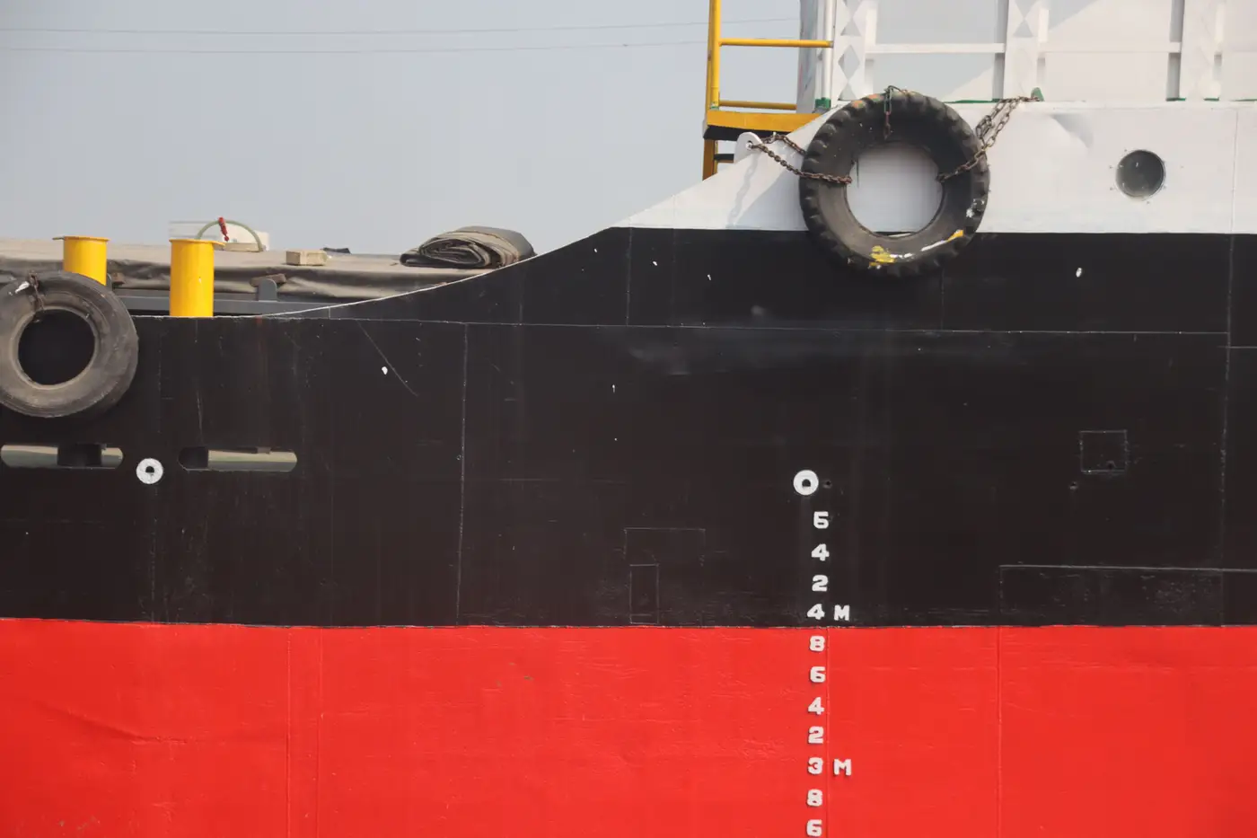
Somebody drops a photo in the chat, usually from a berth cam or a passing tug, and asks whether the vessel is loaded. You zoom in, squint at the bow, and half the time you still can't call it. Draft marks are simple in theory and genuinely hard to read off a casual photo, so here's what actually matters when you're trying to do it from a desk instead of a boarding.
Where the marks are and what they tell you
Draft marks are the painted or welded numerals on the hull at the bow, midships, and stern, usually in meters (sometimes in feet on older or US-flag tonnage), rising from the keel up. The number closest to the waterline, read against where the hull meets the water in the photo, gives you the draft at that point. Subtract the draft from the vessel's known depth (or just eyeball how much freeboard, the dry hull showing above the waterline, is left) and you get a rough read on loading state.
Near the marks you'll often see the load line disc, the Plimsoll mark: a circle with a horizontal line through it and a set of letters (S, T, W, WNA and so on) for different water densities and seasons. That line sets a maximum draft limit, fixed regardless of cargo, and people confuse it with a live draft reading. The draft marks move with the cargo. The load line disc doesn't move at all. If someone sends you a photo and says "the Plimsoll's underwater, she's deep," that's a fair read. If they say "the Plimsoll reads 8.2m," they're describing the draft marks, not the load line itself.
Fouling makes this worse. A hull that's been sitting at anchor for weeks picks up a waterline stain, a greenish-brown band above the actual current waterline, left over from a deeper previous loading. From a bad angle that stain reads as the waterline and throws your draft estimate off by a meter or more. The current waterline sits as the crisp line below that stain, and that's the line worth reading.
Why most photos don't give you a usable read
Angle causes most of the misreads, more than the marks themselves. A bow-on or quarter-angle photo, which is what you get from almost every shore cam, passing ship, or drone clip circulating on a desk, foreshortens the numerals and distorts exactly where the waterline sits relative to them. Two analysts looking at the same oblique shot will call different drafts, sometimes by half a meter, because perspective is doing the work your eye should be doing. Add glare, chop, or a dirty lens and you're guessing.
A photo taken straight down, directly overhead, removes most of that distortion. The waterline sits where it sits relative to the hull outline, full stop, no foreshortening to correct for. That's the difference between a load line reading you can defend in a note to the desk and one you hedge with "looks deep, can't confirm."
It's also why a single freeboard photo from one angle on one day tells you less than you'd like. A vessel riding in ballast on a rough sea state can look deeper than it is; a laden vessel in flat calm water near slack tide can look higher. Without a consistent, repeatable angle and a known cadence, you're comparing snapshots that aren't comparable.
This is the gap Ship Loading State is built around: reading freeboard and waterline from directly-overhead imagery on a weekly cadence, so you get a laden / part-laden / ballast flag with the source image date instead of a one-off oblique photo someone forwarded from a port webcam.
A quick gut check before you commit to a read
Before you flag a draft off any photo, check three things: is the shot close to directly overhead rather than from the bow or quarter, is the waterline you're reading the actual current line and not a fouling stain, and are you reading the draft marks and not the load line disc. Get those three right and a photo read is worth putting in a note. Get any of them wrong and it's a guess dressed up as a number.
If you're tracking a vessel where none of your photos clear that bar, that's exactly the kind of case worth putting on the pilot list.